Geographic Information Science

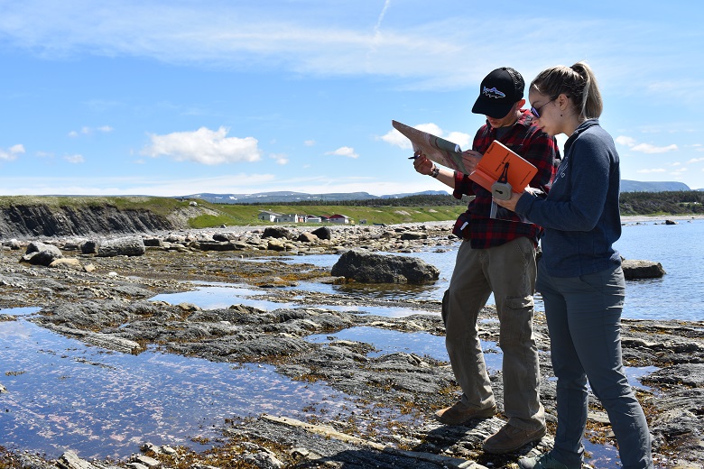
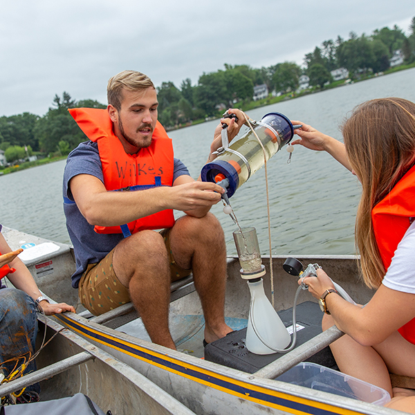
Position yourself to become a leader in the growing field of Geographic Information Science with a certificate from Wilkes University. This hybrid program combines convenient online learning with face-to-face classes and experiential learning.

Program Snapshot

Program Type Format Credit Hours
Certificate Hybrid 15

Why Study Geographic Information Science at Wilkes?

Opportunities for professionals with interdisciplinary skills in geographic information science continue to grow as governments and businesses seek to track inventory, manage resources, make decisions based on geographically based data, and bridge the digital divide.

Apply skills learned in a variety of fields, including:

  • Crime statistics.
  • Natural hazard mapping and prediction.
  • Resource management.
  • Earthquakes.
  • Climate change.
  • Health and disease.
  • Business analytics.

Loading... external website

Program Tracks

Introductory

For industry professionals and community members with no bachelor’s degree, and for students currently working toward a degree

Advanced

For professionals with a bachelor’s degree or some prior experience who want to pursue further skills and Geographic Information Systems Professional certification through the Geographic Information Science Certification Institute

What Will You Learn?

  • You’ll learn theory and practice of geographic positioning systems and fundamentals of geographic information systems, geo-spatial data analytics, remote sensing and cartography.
  • Explore advanced geographic information systems topics such as geo-statistics and geo-spatial modeling, algorithm development and programming, photogrammetry and planetary remote sensing.
  • Solve real-world problems using industry equipment, tools and software, including drones, infrared cameras and high-precision GPS systems.
  • Develop geo-spatial analytics skills.
  • Understand and maintain professional practices and adhere to ethical responsibilities.
  • Acquire the knowledge base and skills to obtain professional licensure and/or certifications in the geo-spatial industry.
  • Gain communications, team building and computing skills required for successful professional practice.

To Apply, Contact

Dr. Bobby Karimi

Associate Professor
Earth Systems Science

bobak.karimi@wilkes.edu
(570) 408-4698

Program Highlights

Hybrid Format

A mix of online and face-to-face classes designed for working adults provide balance between convenience and hands-on learning experiences.

Hands-On

Use equipment and resources that only graduate students get to operate at other schools: high-end GPS units, drones, WARLOC supercomputer and Gigapan, for starters.

Applied Learning

All courses require a project you design from scratch, such as identifying high-phosphorus areas in a lake, or mapping areas of cities out of compliance with the Americans With Disabilities Act.

At Wilkes University, you are exposed to so many different fields of science that you might not even know exist, which broadens your horizons and helps you to find your passion.

Hannah Thornton '20 - Geospatial Analyst

Taking GIS courses at Wilkes University has helped me discuss projects with workers in private and public sectors in visually engaging ways. Having GIS knowledge in your toolkit opens up doors during job interviews and beyond!

Michael Yanchuck ’19 – Air Quality Specialist
2

tracks to choose from, based on your level of experience

1

full year to attain certification, including fall, spring and summer semesters as well as winter intersession

$68K to $85K

Median pay range based on the 2020 U.S. Bureau of Labor Statistics for geographers, cartographers and photogrammetrists

Which Track is for Me?

Introductory

The introductory track is designed for those who want to become well-versed in GIScience and skillful users of GIS software and technology. It’s for bachelor’s degree students at Wilkes or other universities, as well as working adults with no bachelor’s degree or background in GIScience.

Advanced

The advanced track is for professionals with a bachelor’s degree or some prior experience who want to pursue further skills and Geographic Information Systems Professional certification through the Geographic Information Science Certification Institute. This track provides in-depth instruction through advanced courses appropriate to the student’s level and focus. Enrollment to this track requires permission from the director of the Center for GIScience. You must show proficiency of requisite knowledge/coursework to waive introductory courses.

Center for Geographic Information Science

Access Wilkes University’s Center for Geographic Information Science, which brings together faculty experts from a variety of disciplines, including business, and The Institute for Public Policy & Economic Development.

Careers & Outcomes

The geospatial analytics market is expected to experience a 16.9% compound annual growth rate from 2020 to 2027, according to a recent study by Meticulous Research. The field encompasses remote sensing, geographic information systems, global positioning systems to analyze data and assist decision making.

Some industries that employ GIS professionals include:

  • Architecture
  • Engineering and Construction
  • Environmental Consulting
  • Health Care and Public Health
  • Manufacturing
  • Mining
  • Oil and Gas
  • Transportation and Logistics
  • Telecommunications
  • Utilities

Tuition & Aid

Tuition for fiscal year 2023 is $530 per credit, plus a laboratory fee of $120 per credit. Tuition and costs for the full, 15-credit program total $8,550.